Business Details
Trusted Aerial Photography & Video Services in Washingtonville, NY
At AP3, we specialize in aerial photography and video production services for real estate and infrastructure projects. Our team utilizes advanced drone technology and state-of-the-art equipment to deliver high-resolution imagery and actionable data for clients in the Hudson Valley, Northern New Jersey, and surrounding regions. With FAA-certified pilots and OSHA-trained professionals, we prioritize safety and precision while providing tailored solutions for residential, commercial, and construction industries.Our commitment to innovation ensures clients receive geospatially accurate data, including orthomosaic mapping and 360-degree site monitoring, to support informed decision-making. Backed by industry-leading technology and a focus on customer trust, we aim to deliver reliable, high-quality visual content that meets diverse project needs.

Services
Aerial Photography
Drone Videography
Infrastructure Inspection
Construction Mapping
Orthomosaic Imaging
360 Panoramic Views
Highlights and features
- We utilize FAA-certified drone pilots and OSHA-trained professionals for safe, compliant operations.
- Our advanced drone technology captures geospatially accurate data up to 1cm precision.
- We specialize in tailored solutions for real estate, construction, and infrastructure inspections.
- Our team provides orthomosaic mapping and 360-degree site monitoring for actionable insights.
- We maintain a strong safety record and carry full insurance for client protection.
Associations and certifications
- FAA Part 107
- OSHA Certified
Services
Aerial Photography
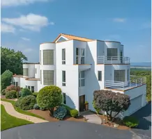
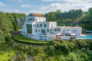
Our aerial photography service captures high-resolution images using advanced drones, providing unique perspectives for real estate marketing and property assessments. We utilize FAA-certified pilots and state-of-the-art equipment to ensure compliance and precision. Clients benefit from visually compelling content that highlights property features and terrain, enhancing marketability and decision-making.
Infrastructure Inspection
Infrastructure inspection leverages specialized drones to assess hard-to-reach areas like power lines, towers, and pipelines. Real-Time Kinematic data ensures geospatial accuracy up to 1cm, enabling early detection of structural issues. This service reduces safety risks and operational costs while delivering actionable insights for maintenance and planning.
Construction Mapping
Construction mapping provides detailed orthomosaic projections and time-lapse imagery to track project progress. Our drones capture high-resolution data for inventory management, safety assessments, and asset tracking. Customizable reporting allows stakeholders to monitor developments remotely and make data-driven decisions in real time.
People
Anthony Cioffi
CEO
Anthony Cioffi leads AP3 with expertise in aerial photography and drone operations. FAA-certified and OSHA-trained, he ensures compliance and safety across all projects. His focus on innovation and client trust drives AP3's commitment to delivering high-quality visual solutions for diverse industries.
Questions
What areas do you serve?
We serve the Hudson Valley, Northern New Jersey, and surrounding regions, including Orange, Rockland, and Dutchess counties.
What industries do you work with?
We support real estate agents, construction companies, solar firms, and infrastructure projects with aerial imaging and data collection.
Are your pilots certified?
Yes, our pilots hold FAA Part 107 certification and are OSHA-trained for safe, compliant operations.
What technology do you use?
We use DJI Mavic 3 drones, Inspire 2 units, and Autel EVO systems for high-resolution imagery and precise geospatial data.
Can you inspect infrastructure?
Yes, we provide drone-based inspections for power lines, towers, pipelines, and other structures with 1cm geospatial accuracy.